
In the wide world of temperature gradients, there is one hard solid line... one that holds true everywhere. 32 degrees Fahrenheit, 0 Celsius... the freezing point of water.
This solid line amidst the uncertainty of weather makes it very difficult to predict what will fall out of the air in some storms. If it's 32 degrees Fahrenheit, and there's no warm air higher in the atmosphere, precipitation will fall as snow. If it's a few degrees warmer, it will fall as rain, or at least as slush. Add to this changes in temperature associated with day and night or with cold and warm fronts, and changes in temperature as one increases in altitude, and you get a real mess.
A mess is exactly what we had last Monday in much of Vermont. A storm hit at night when the air was cold, and it snowed at least an inch or two. But warm air followed, and the snow quickly turned to rain.
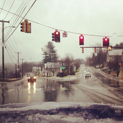
The rain quickly started melting the snow, turning it into slush with the consistency of concrete. Clearing the car window was like trying to remove cottage cheese. The landscape was briefly white and wintry, but soon converted back to what we call 'stick season'- a brown landscape with leafless trees and no snow.
When warm air slips in over the mountains but cold air stays trapped in the valleys, or when a warm front pushes warm air over a cold air mass, things get even more complicated. Snow falling through a warm layer of air turns to rain, but if it re-enters cold air as it falls it can refreeze and turn into sleet. If it doesn't have time to refreeze, it can freeze when it hits a surface, causing freezing rain, also known as an ice storm in severe cases. Extended heavy ice storms can rip huge limbs off of trees, down power lines, and turn roads and sidewalks into sheets of ice. They are beautiful, but dangerous and destructive... true examples of the potency of winter. I've not yet experienced a major ice storm, but I'm sure I will at some point. They do happen in Vermont though they are more common further south.
The weather models mostly predict that we will get more snow next week. We're pretty close to that one hard line in meteorology though... and a change in the storm track could easily mean rain instead, or even an ice storm. Most likely we'll see a little bit of everything, but mostly snow this time... which most people will be happy to see. Then again, the storm could still miss entirely, bringing us nothing. It wouldn't be the first time.
Speaking of storms missing entirely, southern California, which had been quite dry for the last couple of months, had a good soaking rain yesterday, and several more storms are in the forecast. Nothing that is likely to cause flooding like some areas further north experienced recently... but enough to get the hillsides greening up and maybe get some water in the creeks. It should be beautiful. December rain in Vermont isn't particularly welcome, but every rainstorm in the mountains of southern California still seems like a miracle.
We had a storm in Portland last winter that snowed beautiful fluffy snow at about 11pm, but by just after sunrise, the snow was melting and turning slushy. I was disappointed, as I was looking forward to walking through it/playing in it on my way to work that morning. Took me a while to understand how that could have happened.
ReplyDeleteWarm fronts are weird. Are you in Portland, Oregon or Maine? I haven't experienced warm fronts that warm things up overnight in the West, though it must happen sometimes. Here in New England the temperature is often not tied to time of day, especially in winter. Cold fronts are just as weird, sometimes the high temperature is in the early morning and then it drops all day.
ReplyDeleteUpdate: Montpelier is still RIGHT on that line... we could end up with nearly a foot of snow by the end of the week if it's a bit colder than forecast. If it is a bit warmer than forecast, no snow. As forecast, a bunch of slop and ice, and every type of winter precipitation. Unfortunately Burlington and Middlebury will probably have some extended periods of rain. The colder parts of the Northeast Kingdom could pick up quite a bit of snow.
ReplyDeleteThen, around and after Christmas? Too far away to say for sure but there are some indications winter will arrive, late, but not subdued, with subzero temperatures. We'll see...